Always to the frontier

Thursday, January 31, 2013

The Forest Will Not Quit

As hard as it is to believe, large areas of the Front Range in Colorado are still ablaze, even under winter low temperatures and heavy snow-pack.

http://www.coloradoconnection.com/news/story.aspx?id=853700#.UQsLdb88CSo

The forests there have been through really rough patches these past few years, with fire being only the end of problems which have started with drought and climate-pushed insects doing quite the number on the spruce-fir forests.  Still, the western montane forests are incredibly resilient and have to deal with "normal" conditions that make life difficult enough.  Extremely low normal winter temperatures, intense solar radiation, and next to nothing for soil in many locations mean that only the best of the best can even establish here, and they do it well, even when it seems to us that they are struggling miniatures:

Rocky Mountain National Park.  The insect ravaged forests are all those gray-brown patches on the opposite slopes.  You can see a few trees even up here near the treeline.
 

Wednesday, January 30, 2013

Wednesday Filler: Life Outside (and Inside) a National Park

Would that the many parks and preserves in North America stand as the crowning parts of their representative habitat rather than islands among development or commercially exploited lands.  Many if not most are islands, and sometimes within themselves as well.  Death Valley National Park, for instance, is often captured in popular memory as a hot, dry, unforgiving bare bones desert, when in fact it features pine forests, waterfalls, and snow capped mountains.  Saguaro National Park brings us images of pristine desert scenes, when in fact it is being encroached upon by Tucson, and a quick step on either side of the park road gate brings one into an entirely different world of cactus or concrete forest.

So it is with Sequoia National Park, where the big trees are hardly the only feature even in the park itself.  Much of the lower elevations of the park are wonderful reaches of the California chaparral world, while other parts are dry open oak forests with yuccas abounding.  While not the big trees that inspire awe and amazement, these environments are worthy of exploration and a reminder that while the purpose of a park is to preserve and allow everyone to enjoy our national treasures, a park also exists to remind us that the world outside its boundaries, while not protected, is every bit as amazing and worthy of more than a second thought.


Tuesday, January 29, 2013

Crown Point, Indiana

Northwestern Indiana is a unique part of the state as much economically and demographically as it is naturally.  As if human culture were trying to stick to natural drainage patterns and ecotones, heavily industrialized Lake and Porter counties contrast with the rest of the agrarian state.  Even the other large cities such as Fort Wayne and Indianapolis do not feature manufacturing and refining as their main events.  Gary, on the other hand, has industry for its lifeblood.

Those blurry bits on the horizon are huge refineries and processing mills that surround the undeveloped shoreline of the Dunes national and state parks.

Head south enough, even within the two south shore counties, and one can find "Indiana proper" slowly emerging, along with a domestic and civic architecture one would expect to find from the true Midwest.   I covered what one could typically find in a Midwestern city center back on a post which featured a few downtown shots of Independence, Missouri .  Picture the downtown from "Back to the Future" (despite it being supposedly set somewhere further west) and you get your classic Midwestern townscape, complete with a central government building, a movie theater, and a bunch of shops set around the main square.  As noted in the earlier post, the civic planning is based on a strong democratic basis of a culture that focuses on interdependent family and small town ties, along with less of a focus on commercialism and more of one on public gatherings.  Still, this is the "cultural ecotone" of northwest Indiana, and the landscape here is just a little bit different.  Case in point: Crown Point.  The pictures, I think, can speak for themselves.


The courthouse.  John Dillinger escaped from here!


Monday, January 28, 2013

Lake Michigan's Southern Shore: North Meets West Meets East

Dramatic stands of Eastern White Pine (Pinus Strobus) and Jack Pine (Pinus Banksiana) grow among Big Bluestem (Andropogon Gerardii), Eastern Prickly Pear (Opuntia Humifusa), as well as a variety of trees common to the eastern forests, notably oaks, hickories, ashes, willows, and more.  In a low, watery basin sits a spahgnum bog topped with boreal species, mere yards away from an open prairie, in turn yards away from an ash swamp, which sits behind cool depressions in sand dunes which give rise to great pines.  This meeting place is the world of the Indiana dunes, a natural point of junction that has also served as a great crossroads for people traveling between various parts of the continent.

Sand, wind, and glaciers are responsible for bringing together a diverse community of plant life that serves to defy definition for the area.  My first sign that I was in an altogether different place was the presence of so many White Pine that just popped up out of nowhere.

Both shots taken at Indiana Dunes State Park near the end of State Park rd.


Now normally when one comes across such stands so far south it is because park agencies would have planted them to add exotic interest to the environment, an attempt to create something of a "north woods mystique" to state and local campgrounds.  Pines might have existed here naturally at one point, but most that are seen south of the Great Lakes are nostalgic reminders of a timer before the great lumber pillage of the nineteenth century.  Here, however, they remain as relics of the huge stands that once helped to build Chicago.  They rise from the sands in scenes expected hundreds of miles to the north in northern Michigan and Ontario.  Travel only a few miles south, over ancient moraines left at the edge of long vanished ice sheets, and the sand is left behind to be overtaken by rich prairie soils and more temperate forests.  This is, after all, Indiana, a place one would hardly expect the north to thrive in.

Yet thrive it does.


But the north here is not alone.  The dunes are first stabilized by dune grasses...


...and more southerly trees like Eastern Cottonwoods (Populus Deltoides) and Eastern Redcedar (Juniperus Virginiana).


Eventually they are joined by trees found in more mature forests as richer soils are built up in the ever changing world of our eastern plant succession forests.  In some lower places, water stands for a significant portion of the year, and we have moist forests of ash trees, Swamp Cottonwoods (Populus Heterophylla), and other water tolerant trees.


Eventually the lake gets far enough away that its power over the shifting sands declines along with the sand itself.  Departure from the drainage basin of Lake Michigan marks an ecological departure into the Midwest, where a new struggle of plant succession takes place, waged not between sand and plant but fire and plant.  A mosaic of prairie, savanna, and forest stretches in all directions but north from atop the Valparaiso Moraine.  Looking north instead shows us what we have just seen, a meeting of north, east, and west.  These days humans mimic this corridor along our highways 20, 94, and various railroads.  Come by tomorrow for a look at the human presence in Indiana's "southern shores".

Sunday, January 27, 2013

Northwest Indiana: A Little Different

Time and again I have disagreed with the majority opinion regarding how we ought to define the Midwest.  Much of Ohio and Michigan just do not qualify to be truly part of the Midwest, with a good chunk of Wisconsin and bits of Minnesota not quite making the cut either.  Geographically, climatically, botanically, politically, culturally, and in so many other ways, these places are a distinct region better named for the Lakes which they embrace, and for the northern lands which they form the southern edge of.  Just beside them, however, are places that take on a different character almost immediately.  One such place would be Indiana.

Indiana has what one would definitely come to expect from the Midwest, even as it shares a few features in common with the Lakes region and the American South.  In the northwestern corner are a variety of human and natural features which mark a very rapid transition into something Midwestern.

Just south of Hobart, Indiana.

While Ohio and Michigan have their fair share of farms and quite open rural country, Indiana is positively dominated by it.  Even before the second born of our continent changed her face into what we have these days, Indiana was the first place heading west where one would find open prairies, some large enough so that a treeline on the horizon was barely noticeable.  The result was that settlers took quite readily to open spaces with excellent soils, and the place became a state as quickly as 1816.  They and their descendants formed an agrarian minded populace that has since become associated with the "heartland", and everything from their accents to domestic architecture reflect this quite well.


That said, the state was (and is) something of a highway as much as a destination.  People came to Indiana on their way to something else as often as they broke ground, enough so that the place has been self-proclaimed as the "crossroads of America".  In the northwestern corner of the state, this is perhaps all the more true.  While most western migration routes followed the main rivers and more southerly wagon trails, a connection to the Great Lakes was important enough that Indiana demanded a little bit more of it from Michigan, a territory which would have claimed land as far south as Gary.  The connection to Lake Michigan is indeed very tenuous compared to the rest of transit networks in the state, a situation reflected in the relative  lack of a drainage basin emptying into big blue.  Mere miles is all the grand lake can fetch in some places, while the Mighty Mississippi steals the rest.  Mere miles, however, is enough to produce a part of the state just a little different enough to make it a very special place.  This is dune country, and this is more of what we will explore tomorrow.

Saturday, January 26, 2013

A Birthday Card for Michigan

Northwest Indiana can wait until tomorrow, especially considering the significance of today.  Michigan turns 176 years young today.  Accordingly, I present to all my readers a few key shots about what our great state is.  We might have once pined away for a little bit more of Ohio and Indiana, but when we finally ended up with our current boundaries we came across with a way better package.

Michigan today is all about industry and agriculture of all sorts, with cities and towns made up of peoples from every corner of the globe, but at a more primal and natural level we are one side of the coin which we make up with Ontario in a beautiful backdrop for some dramatic and powerful lakes.  We are a southern peninsula which is often mistaken for more of the typical flat expansive farmland of the true Midwest.  Call me blindly devoted, but we are a bit more than that down here:

Taken at the top of the dune at Pyramid Point in Sleeping Bear Dunes National Lakeshore.  

For that matter, we are an even more, yes, mountainous land of lake and borderline boreal forest in our northern peninsula:

Taken from the back porch of Epoufette Bayview Inn in Naubinway, Michigan.

And yes, we are a land of steel and furnace, and our two portions are connected by a great symbol of our industry:

Just outside of the toll plaza looking south from one shore to another.

This bridge, our "Mighty Mac", crosses our intensely lovely waters which can more than hold a candle to the most postcard perfect oceanic treasures of the Caribbean:

A little bit more of Sleeping Bear Dunes National Lakeshore, this time at Glen Haven.

We are not only a land of shore, however, and have amazing forests:

In the spring brush at Island Lake State Recreation Area.  Here we have a very mixed forests of everything from oaks to maples along with our state tree and dominant forest feature, especially historically, the Eastern White Pine (Pinus Strobus).

And savannas and even prairies:

Also from Island Lake, a picture perfect remnant of the grasslands which once hypnotically attracted settlers.

From top to bottom.  Finally, in our present age, the age of Mighty Mac and a few centuries prior, we are a land of many cultures and a passageway of exploration, commerce, and both war and peace.  While we share a border by land and lake with five other states (Illinois and Minnesota across the waves), we share a history with a neighboring country, and especially a neighboring province, that we have much in common with.  As I claimed, we are one side of a coin that could also be likened to one part of a sandwich that hugs Lake Huron.  I believe our future definitely lies in rediscovering this relationship.

From the southern tip of Belle Isle.  Seriously people, go explore this gem of a park!

Happy Birthday, Michigan!  Some say you are pure, some say you are messy, but you are home to nearly 10 million of us humans and quite a lot of deer, as well as this proud Michontarian.

Friday, January 25, 2013

Lake Michigan From the Bottom

Really from the bottom, in Indiana, and at a low angle just over this lovely little sand dune.

The beach at Indiana Dunes State Park, an enclave of Indiana Dunes National Lakeshore.

The scale is a bit misleading, as the dunes are anything but flat.  The rest of the area is pretty pancake though, at least until you hit the Valparaiso Moraine.  Come by tomorrow for some more detail!  The next few posts will feature the softer side of heavily industrialized northwestern Indiana.

Thursday, January 24, 2013

Lake-Effect Snow

Those of you from lands apart from major bodies of water might hear the term mentioned in the title and scratch your heads about what it means.  Sit in the darkness no longer, for here I shall expose the truth behind the legends in all its furiously frozen glory.

This is actually a pretty clear shot, with the fuzz you see being snow.  Lots of snow.  I drove through this yesterday on that lovely stretch of I-94 between the Indiana border and Kalamazoo, Michigan.

Lake-effect snow, as you can see, is often no fun at all.  It can stop highway traffic dead in its tracks, close even the greediest of chain retailers, and definitively bring out the most pessimistic attitudes in even the most enraptured winter lovers.   Plains folk might go on about their Alberta Clippers and Fargo blizzards, and New-Englanders might bemoan Nor-Easter's, but for sheer snow upon snow, little can beat the power of a Great Lake transferring moisture onto a much colder land mass beside it.  Any resident of Oswego, New York, in fact, can testify how powerful Lake snow can be.  They have experienced five feet in as many hours!  Many nearby cities in Western and Central New York will often compete for a title of the "Golden Snowball", with Buffalo and Syracuse usually getting over-dramatic in competition for the dubious honor.

Where does most of this stuff happen anyway?

Public Domain, courtesy NASA.

Mostly on the western and south-western shores of the Great Lakes.  The western end of Lake Ontario definitely receives more than a fair share of snow, but things are hardly better off on the other lakes, as one can easily see from the image above.  In my personal experience, I would have to say that that western end of Lake Ontario does win the prize for sheer amount in a shockingly rapid time, but for a constant barrage, the northwestern corner of Michigan's lower peninsula, the stretch of shore from the Pennsylvania-Ohio border to southern Buffalo, and above all else, Ontario west of the southern end of Georgian Bay are the places that I have consistently seen buried.  Orillia, Ontario, I would have to say is the most in need of shovels and plows; from November until late March the area is buried in a snow pack worthy of the higher slopes of the Rockies.  The Muskoka lakes to the north of the city get so much snow that gets so densely packed that one can wander out onto their frozen surfaces and think one was walking on ice rather than several feet of snow.

For all the fluff that our lakes can pass on to their terrestrial neighbors, this snow is just that: fluff.  The clouds rapidly lose power as they dump their loads on the land, with few systems making it past 60 miles inland.  The bands are also limited in that they really don't alter existing storm tracks and weather patterns that much. Sure, if a winter storm hits Traverse City or Rochester, it is going to dump both its load and some lake effect on the cities, but the storm will then shed the additional help and move along as intended.  One can easily move north or south out of the bands of snow coming off the lakes and find next to nothing mere miles away from the heaviest falls.  Yesterday I saw no snow cover in Indiana until I was within yards of the Michigan border.  Immediately upon crossing (and thus being east of Lake Michigan) flurries picked up until only a few miles later several feet of snow was covering everything.  One can be in north Buffalo and stare at a brown lawn while one's friends in Lackawanna will be begging for the snow to stop as the fruitlessly shovel out their driveway.  Port Huron today received two inches of snow while Sarnia is covered in a fresh ten inches.

The snows do not always hold to tradition, however.  Bands coming off of Lake Huron have interacted with extremely cold temperatures over the Algonquins and Laurentians and traveled as far away as Quebec and Maine.  Sometimes the wind can blow in the opposite direction and dump on places like Chicago or the parts of metro Detroit west of Lake Saint Clair.  All the necessary ingredients are there, after all.  The lake has yet to freeze, the land is much cooler, and the transfer of water simply takes on a new direction at the whim of the wind.  Lake-effect does not even need the Great Lakes to happen.  Salt Lake City can see a load of snow because of nearby Salt Lake, and back in 1977-1978 during the winter of winters, Tampa even saw "bay-effect" snow as the Gulf of Mexico dumped a load on the city.  We Lakers just happen to see this sort of thing a bit more often, and we gladly accept it in return for amazing summers blessed with natural air-conditioning from our same lakes, along with incredible beaches and sunsets.

Saturday, January 19, 2013

The Leaning Hydro Towers of Hoover Dam

In an earlier post regarding those ubiquitous electric towers I made mention about the pylons sticking nearly horizontally out of the cliff face above the Colorado just below Hoover Dam.  It turns out I do have a picture of them available, and a rather nice one of part of the dam itself.


I kept looking at the things thinking they would fall over.  In some ways, I find them every bit the engineering marvel that the dam itself is.  I imagine that they could have easily been anchored more securely standing straight up, as the Niagara pylons are at both the Canadian and American power stations, but maybe here we just had an engineer adding one more extreme to an already dramatic place.  

Thursday, January 17, 2013

Canadian, Texas

Yes there really is such a place.  The town of Canadian sits above the Canadian river in the Texas Panhandle.  While it did not really stand out anymore so than most other panhandle towns, its more of an oasis than the other ones can be.


The Canadian River, like the other exotic rivers (a river which stays wet and runs throughout the year in an otherwise dry area, like the Nile through the Sahara) of the Great Plains, is something of a welcome refreshment along much of its course.  It carves out a bit deeper of a valley than do the Arkansas, Platte, etc.  The result is an exciting sudden change from rather desert like surroundings...

All pictures in this post were taken along southbound US 83.  The "mountains" in the distance are actually part of the valley edge, and the green immediately beneath/in front of them would be the verdant vegetation of the river bottomland.

...into something remarkably lush.

What a messy window!

The town, in fact, is self-called the "oasis of the Texas panhandle".

The name Canadian probably has little to do with the namesake northern lands quite some distance away, but rather more so to do with an English corruption of the Spanish word cañada (which is nearly cognate with our word canyon) which translates as glen, valley, or, you guessed it, canyon.  The Texas panhandle has many such features, including the more famous Palo Duro Canyon.  Of course, the romantic French-Canadians among us might think it an homage to times past when this was frontier territory marking the boundary between New Spain, later Mexico, and New France, later Canada.  Yes, the summers might be brutal compared to anywhere in Quebec, but there were still once beavers in the river swimming alongside the armadillos and plaid-shirted lumbermen wooing terrified Tejan debutantes.  Alas...

Monday, January 14, 2013

Yes, There are Trees in Kansas and Nebraska

People sometimes ask how anyone can stomach driving across the plains through boring "fly-over" states such as Kansas or Nebraska.  They envision long, straight, flat stretches of land with nothing but corn extending into the horizon, perhaps at sometime replaced by open grass range.  While I could humorously make the claim that they are missing the forest for the trees and ignoring the majesty of the open grasslands and incredibly huge sky, such places are often better defended by stating that trees actually do exist in nearly all of non-tundra North America.  No, they might not be towering cathedral pillars as they can get to be in the northwestern or eastern forests, but they are hardly shrubs either.
 
This and below were taken at Tallgrass Prairie National Preserve near Council Grove, Kansas.

Each of the plains states and provinces, in fact, have arboreal symbols, some of which tend to surprise people.  Oklahoma's state tree is the Eastern Redbud (Cercis Canadensis), while chilly, open North Dakota's is the American Elm (Ulmus Americana), a tree of great size and commonly a beloved landscape plant throughout eastern North America.  Kansas and Nebraska offer the more common Eastern Cottonwood (Populus Deltoides) which can be found anywhere on the Great Plains that enough water has been provided for the plant to get its start.  Many historic routes and modern highways, in fact, are never far from the reassuring marching line of cottonwoods rising above the grasses and willows as signs of readily available water running along with them.


While the Trans-Canada highway, I-90, 70, and 40 make a clear shot across the grasslands, I-80 stays with the cottonwoods in much of Nebraska as it strikes west along the Platte River.  (See: "Green Is My Platte Valley").  Most towns spring up on the horizon with more trees than buildings in site, even on the high plains.  The truth is that there is enough groundwater and precipitation here that a planted tree can thrive quite well.  Nebraska, in fact, has quite national forests enough to green up the map as much as the eastern states can get painted over.  Grasses are the reason such trees can usually thrive in the first place, their roots being excellent retention agents for water and responsible for making the soil of the plains so workable to begin with.

While the trees do diminish naturally the farther west one goes, to the point of almost negligible forest cover in the rain-shadow of the Rockies, river courses and even slight sharp rises (such as bluffs) will feature some sort of tree cover.  In something of a parley of the trees, east and west invisibly meet in this great division point of North American botany.  Cottonwoods, willows, elms, and cedars follow river courses while they are seemingly watched by western pines and junipers atop river bluffs.

Sunday, January 13, 2013

Sunday Post: Balancing Act

Our dry continent has a scenic advantage over wetter parts of the world.  We have amazing rocks here.  Since my recent days have become something of a topsy turvy adventure, I figured I might post this wonderful shot from Arches National Park.


Arches is often described as a place that you not only must see before you die, but must see soon before it falls apart.  While the process of erosion is not nearly that dramatic on the dry Colorado Plateau, things do still crumble now and then.  Arches, like much of the plateau, is a great way to introduce kids to the magic of the natural world, and the wonders here are enough to usually make even the skeptical adult take a second look.

As you can see, it is also full of life.  The smells after a fresh rain are beyond compare.  

Friday, January 11, 2013

105 Years Ago

On this day, the Grand Canyon became permanently protected.


Both shots are from the north rim, which is an absolutely beautiful way to experience the canyon.

We might think that no one could want to harm this vista and land, but the truth of the matter is that hordes of miners were eyeing the exposed geology with riches in mind beyond the dreams of avarice.  Later on, even as a park, the thing was almost flooded for dams!  We have since come to recognize the greater value of this and many other wild lands.  Still, if people fought over something so obviously scenic and powerful, you can imagine how the struggle continues to protect lands (including just plain old water sources) that hold no apparent immediate value.

Tuesday, January 8, 2013

Monday, January 7, 2013

What Once Was

When the first European colonists of the United States and Canada arrived on these shores, there was little to make them stay other than the possibility of riches, mostly in furs.  Sure, liberties so far from the mother countries could be taken, but along with freedom came a rugged existence in lands of wild animals, exotic natives, and winters that would severely test the European endurance.  The land was not much more fertile than what they had left behind, at least not on the coasts.  Mineral resources did not lie exposed for easy pickings.  The weather, as noted, left much to be desired, especially in the extremes of winter and summer.  Something did catch the eye almost right away though. and it was something that none of the forests of Europe could then hold a candle to: our trees.

Many trees became valuable export commodities, not merely for the lumber, but for the specimens themselves.  Rich landowners in Europe wanted to get their hands on exotic plants of all sorts from the New World, even as the newcomers brought plants of their own with them.  One tree stood out in particular, making the timber riches of the Baltic nations even pale in comparison.  Botanists came to name it Pinus Strobus, but we know it better as the Eastern White Pine.

All but the last one of these pictures are taken on or near Cedar Lake in Ontario.  

It is one of, if not the, most magnificent trees in the world.  The tallest specimen currently living in the world is the Boogerman Pine, 207 feet tall until it was cut a bit short by a storm in 1995.  It tops out at 186 feet currently, and can be found in all her glory in the Great Smoky Mountains, quite near the southern limit of the White Pine.  She has wonderful conditions in which to grow, namely having a decent growing season and some of the highest rainfall totals (while also being extremely well drained on a slope) in eastern North America.  Still, she is small.

Why do I say this?  Colonists reported trees that would have made her look a bit short.  Early English and French settlers were prone to exaggeration, but they also had to sell their native assets to prospective buyers back across the ocean.  Capitalists could profit off of myth under the right circumstances, but they could also be quick to bust stories if exaggerations got in the way of the bottom line.  Reports of trees rising more than 250 feet into the air were not uncommon, and Eric Rutkow suggests that this made the colonies expand beyond their statuses as mere small-scale social enterprises.  (His book on the matter can be found here.)  Today we have not even a single tree that can boast this size, with the average old growth canopy topping out at 120+ feet.


Still, such trees are reminders of what once was the impressive eastern forests.  Whenever anyone decries the existence of the national parks in our countries, I usually ask them if they have ever experienced one first hand.  The response is typically a firm "no", followed by a claim that while the forests are pretty, they are hardly as impressive as I make them out to be.  The Grand Canyon?  The Rocky Mountains?  Worth saving.  The Cuyahoga Valley?  Acadia?  Shenandoah?  A nice Sunday drive, but little more than undeveloped land, and not worth putting a budget behind, much less worth protecting.  (Yes, people do think this way).  Of course, these people ignore much of the general miracle of nature and life, existence really, that can be found on a front lawn, and tend to want some big, impressive feats of power and growth to be impressed.  I usually have one more question for such people in my arsenal:  Have you ever experienced a supercanopy?

The picture above are shorter examples of what consists of a supercanopy.  More than any other tree in the world, with the exception of the Giant Sequoias and some species of wax palms in South America, the Eastern White Pine is associated with the concept of supercanopy.  These are trees which form an even higher layer of arboreal life above the main treetops, in some ways forming a second forest in the air.  Finding such trees are very difficult these days, but the early colonists would have experienced such forests stretching from Minnesota to Nova Scotia and south along the Appalachians.  While a group of high risers would have been impressive, sometimes a single tree bursting from the forest can illustrate the effect even more.


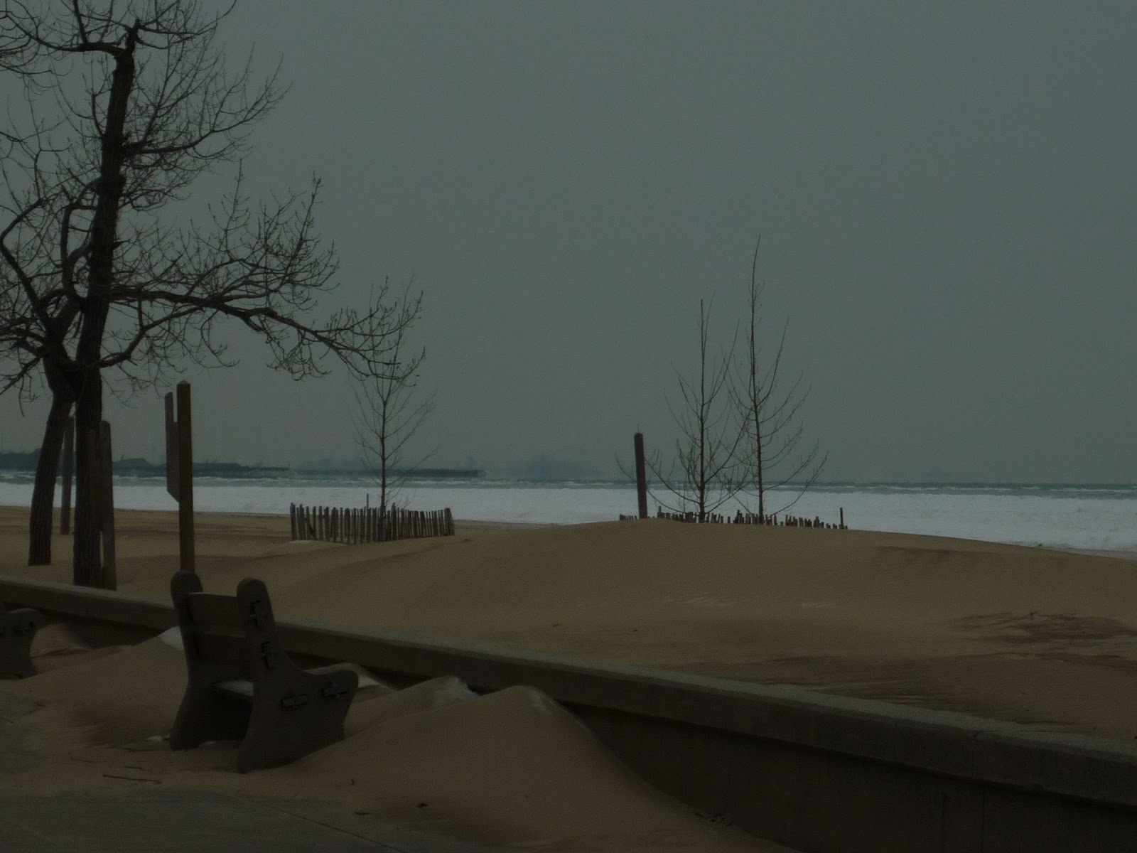
As noted, we have very few such trees at which to marvel these days.  More often than not, we now appreciate the White Pine for its sweeping, elegant branches and dramatic locations of occurrence  often exposed to the full force of the elements not from above the forest, but at the edge of it, usually along a lake.


Oddly enough, perhaps it is because of its beauty and relatively frequent occurrence as a smaller, shapely tree that we do not take notice of it the same way that our ancestors did.  It remains a popular landscape choice, but all too often is second fiddle to trees which have lovely blossoms or exotic foliage.  Now, perhaps, it is an accent piece rather than the main event of the eastern forests.  Corporate timber interests have yet to disappear, however, and as our trees grow tall enough again, they will surely attract attention, even in a more conservation-minded age.  After all, we tend to want to preserve only the oldest and grandest things, rather than the accent pieces.  We are drawn to immensity as if it had a magnetic attraction to us.  Perhaps we are not so different from our ancestors.

Our second-growth forests may one day then be able to slowly grow up in anonymity while we chase after more easily extracted resources and bigger and better things.  We may one day have our grand colonial forests once more.  In the meantime, stands of pine and notable accent pieces do have the power to attract attention, especially when moving north into the transition zone toward the Boreal world.  White Pines are among the first "northern" tree one comes across when heading toward the northern woods, and like the peacocks of the tree world that they are, they tend to put on quite a show.


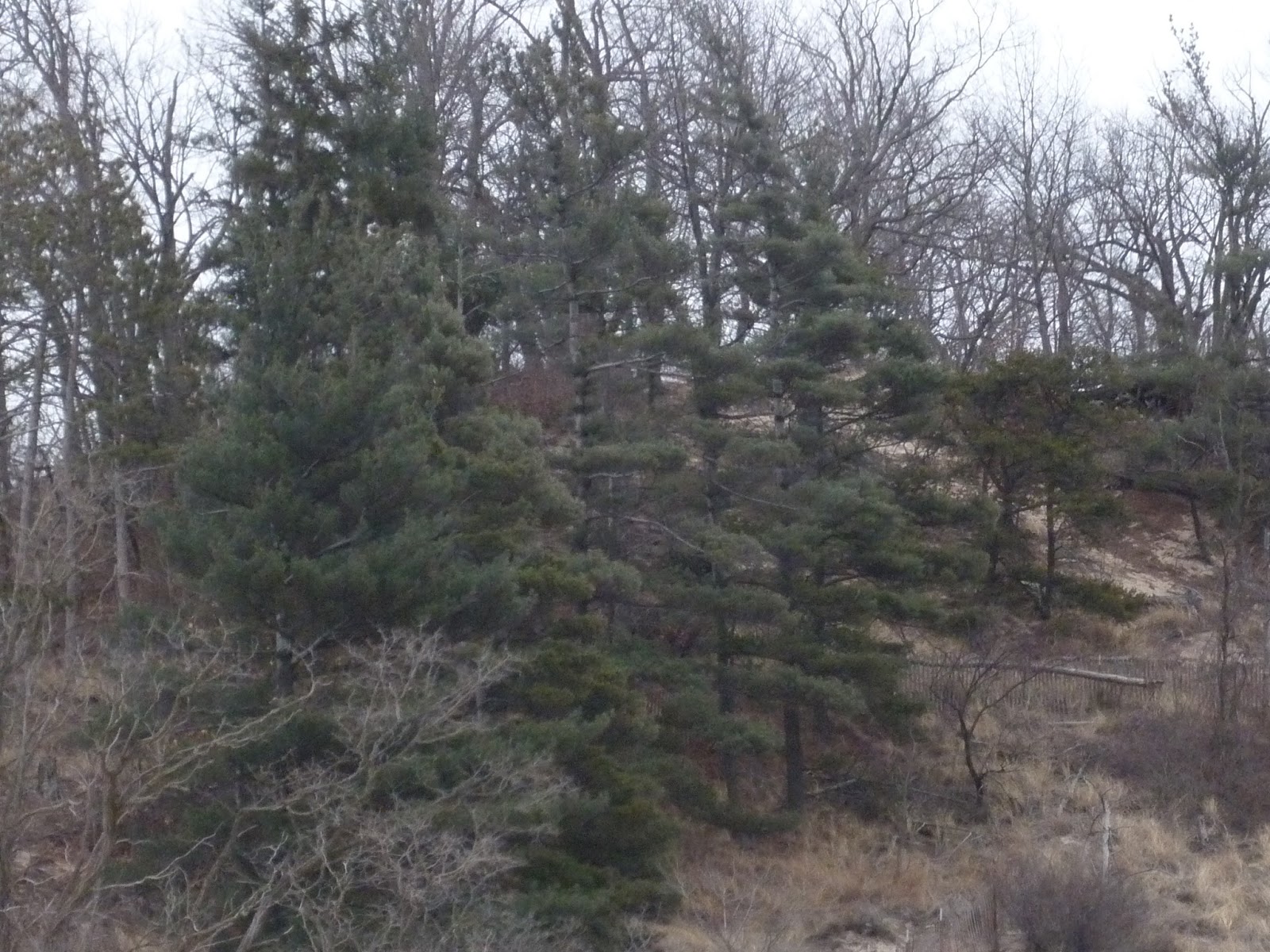
This one is from Michigan, probably somewhere in Benzie county, but I can't seem to recall off of which road exactly.